- Home
- About TBT
- Products
- Material
- Cement
- Concrete
- Asphalt-bitumen
- Soil
- In-Situ Testing
- Tri-axial Test Apparatus
- Consolidation Testing Machine/Consolidometer
- Shear Testing Apparatus/Machine
- Compaction Test Machine/Compactor
- Permeation/Swell Testing Apparatus/Permeameter
- Density Testing Machine/Apparatus
- Soil Moisture Meter
- Atterberg limits / liquid plastic limit
- Other Equipment/Machine
- Geotextile & Geosynthetics
- Pavement
- Rock
- Aggregate
- Geological
- NDT
- Petroleum
- Ceramic
- General Lab
- PH Meter
- Conductivity Meter
- Biochemical Analyzer
- Centrifuge
- Furnace/Drying Oven
- Electric Balance
- Thermometer/Hygrometer
- Microscope
- Whiteness Tester/Color Meter
- Ball Mill
- Vacuum Pump
- Magnetic Stirrer
- Refractometer
- Indicator Paper
- Supersonic Cleaner
- Water Bath
- Spectrophotometer(UV/VIS/AAS)
- Viscometer
- Cuvette
- Environment Meter
- Other Equipments
- Color Meter / Gloss Meter
- Rubber-Plastic
- Surveying
- Paint
- News & Events
- Download
- Contact us

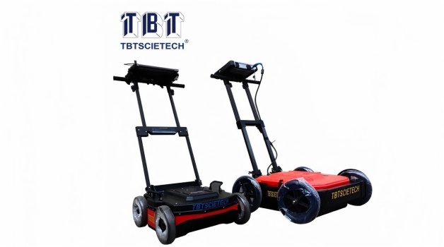
Mapping Subsurface Features with Ground Penetrating Radar(GPR)
Ground Penetrating Radar (GPR) systems have revolutionized pavement testing by providing non-destructive and highly accurate methods for mapping subsurface features. In this article, we'll delve into the significance of Ground Penetrating Radar in pavement testing and explore its applications in detecting and evaluating subsurface anomalies.
Understanding Ground Penetrating Radar
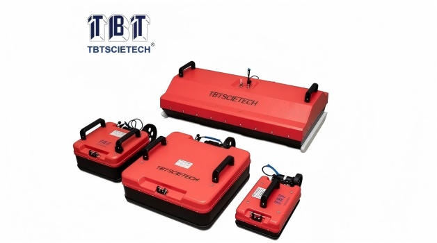
Ground Penetrating Radar is a geophysical technique that uses high-frequency electromagnetic waves to penetrate subsurface materials and generate detailed images of underground structures. By analyzing the reflections of these waves, Ground Penetrating Radar systems can identify various subsurface features, including voids, cracks, rebar, and utilities, without the need for excavation or drilling.
Non-Destructive Testing:Unlike traditional methods such as coring or excavation, Ground Penetrating Radar allows for non-destructive testing of pavements, minimizing disruption to the surface and reducing project costs and time.
High Resolution Imaging: Ground Penetrating Radar systems provide high-resolution images of subsurface features, allowing engineers to accurately identify and assess potential issues such as voids, moisture infiltration, and pavement thickness variations.
Real-Time Data Collection:With advancements in Ground Penetrating Radar technology, data collection and processing have become faster and more efficient, enabling real- time analysis of pavement conditions and facilitating timely decision-making in maintenance and repair projects.
Pavement Condition Assessment: Ground Penetrating Radar is used to evaluate the condition of pavements by detecting subsurface defects such as cracks, voids, and delamination. This information helps transportation agencies and contractors prioritize maintenance and rehabilitation efforts.
Subsurface Utility Mapping: Ground Penetrating Radar is employed to map underground utilities, such as pipes, cables, and conduits, before pavement construction or repair activities. This helps prevent accidental damage to utility lines and ensures the safety of workers and equipment.
Pavement Design and Construction: Ground Penetrating Radar data is utilized in pavement design and construction to determine pavement thickness, identify weak zones, and verify the integrity of underlying layers. This ensures the durability and longevity of new pavement structures.
Ground Penetrating Radar systems offer a powerful solution for mapping subsurface features and assessing pavement conditions with unmatched precision and efficiency. By leveraging the capabilities of GPR in pavement testing, engineers and transportation agencies can optimize maintenance strategies, prolong the service life of roadways, and ensure the safety and reliability of transportation networks.
In conclusion, Ground Penetrating Radar plays a crucial role in pavement testing by providing valuable insights into subsurface conditions and facilitating informed decision-making in pavement management and construction projects. As technology continues to evolve, Ground Penetrating Radar systems will remain indispensable tools for maintaining and enhancing the performance of transportation infrastructure.
 Contact person: Ms. Toni Gu
  toni_gu@tbt-scietech.com sales@tbt-scietech.com
 0086-25-8472 1577 / 8472 1579 / 8472 1907
 Mobile / WhatsApp: 0086-138 5170 2127
 0086-25-8472 2235
 Rm. 2903-2904 HuaXia Mansion, No. 81 ZhongShan Rd.,


Copyright © 2021 Nanjing T-Bota Scietech Instruments & Equipment Co., Ltd All Rights Reserved